Taibilla Reservoir
Background
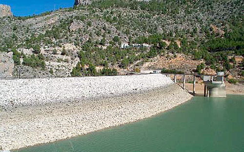
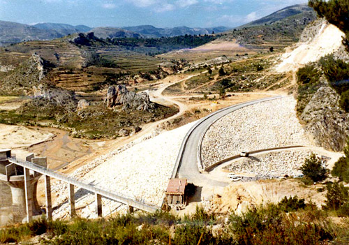
The first project for the construction of a dam on the River Taibilla was drawn up in 1918 by the Confederación Hidrográfica del Segura. Its site was to be the Estrecho del Aire (which is the ski-jump spillway area of the current dam).
Following the preparation of the project and the reform projects, which did not include geological studies, work was begun in 1926. On excavating the foundations, the possible unfeasibility of the project was observed because of tectonic and permeability problems of the natural downstream boundary for the storage area.
From that moment, between 1928 and 1930, three geological reports were drawn up with the initial aim of studying the Estrecho del Aire natural downstream boundary, but the above-mentioned problems led to other sites being studied, one of which was to become the site of the dam today (a few metres upstream from the Estrecho del Aire).

From the information contained in the geological reports and the recommendations to change the site of the dam, the preliminary project for the Turrilla dam was presented in 1935. This was a rockfill dam with concrete facing located in the same area as the current dam.
On 29th July 1966, the Ministry of Public Works took the decision to “Order the Mancomunidad” to draw up a plan for the works required to meet the supply needs of the area under its jurisdiction for the following 20 years. Following the study of the needs and the preparation of a preliminary project for the works required, the drafting of the dam project was authorised in 1967.
After the project had been passed in 1969, there was a public tender for the “Taibilla Dam” works.
The document verifying readiness for construction was issued on 22nd June, 1970.

It should be mentioned that the project drawn up was incomplete as it required a scale model study of the functioning of the spillway, regarding which, in an earlier study, it had been recommended that the latter be extended to rejoin the river course downstream from the dam in the calcareous gorge formed by the Estrecho del Aire, although the report was made known before the project was awarded.
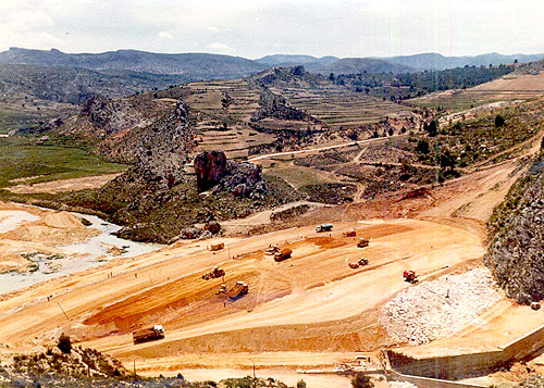
The works began on 1st July.

Access
Access is via the Canal Alto del Taibilla service road, which heads southwards from kilometre 35+050 of the MU-706/AB-702 road between el Sabinar and Nerpio.
With the construction of the Canal Alto del Taibilla, an access road was laid from the AB-702, El Sabinar to Nerpio road 10 km from El Sabinar. One follows the road for 6 km until reaching “Presa de Toma de Agua del Taibilla” (Taiblilla Diversion Dam).
There is another access to the dam, from Vizcable via Yetas, which is much longer, although it is an alternative if the service road is closed because of rock falls.
This was presented as a separate project and is a service road for the whole Canal del Taibilla.
The location of the reservoir can be seen in the following map:
Characteristics
|
LOCATION OF THE RESERVOIR
|
|
|---|---|
|
Province
|
Albacete |
|
Municipality
|
Nerpio |
|
River
|
Taibilla |
|
Hydrographic basin
|
Segura |
|
DETAILS OF THE BASIN
|
|
|
Surface area of the reservoir basin
|
318,00 km² |
|
DETAILS OF TAIBILLA RESERVOIR
|
|
|---|---|
|
Shore length
|
1,50 km |
|
Reservoir surface area
|
82,53 ha |
|
Reservoir volume
|
9,5 hm³ |
|
BODY OF THE DAM
|
|
|---|---|
|
Type
|
Loose Materials |
|
Materials
|
Loose Materials |
|
Upriver slope
|
2,2/1 (h/v) |
|
Downriver slope
|
2,05/1 (h/v) |
|
Height above course of river
|
34,00 m |
|
Level of crest (eje de calzada)
|
956,30 m |
|
Crest length
|
271,00 m |
|
Crest width
|
8,43 m |
|
Total volume of materials
|
590.000 m³ |
|
SPILLWAY
|
|
|
Number of Spillways
|
1 |
|
Type of spillway
|
Circular in vertical well Morning-Glory type. |
|
Number of openings
|
6 |
|
Total free length
|
48,20 m |
|
Administración
|
Mancomunidad de los Canales del Taibilla |
Purpose
The Mancomunidad de Canales del Taibilla was set up in the first half of the 20th century to supply the municipal districts that formed part of the Mancomunidad: Cartagena, Murcia, Lorca, Orihuela, Elche, La Unión, Mazarrón, Totana, Ceheguín, Moratalla, Mula, Fuente Álamo, Alhama, Bullas, Torres de Cotillas, Librilla, Pliego, Crevillente and the Cartagena Naval Base. Also included in the supply were municipal districts which were convenient to supply and the study to supply the former, easy to make: Férez, Socovos, Caravaca, Villanueva, Ojós, Ulea, Archena, Ceutí, Alguazas, Lorquí, Molina de Segura, Alcantarilla, Santomera, Benferri, Redován, Callosa de Segura, Almoradí, Cox, Albatera, Catral, Dolores, Santa Pola and Alicante.

To do this a Base Project (1930) was drawn up for the planning of the necessary work for the exploitation of the Taibilla river basin. This consisted basically of the Water Intake from Taibilla reservoir and its transfer to the municipal districts cited via the main canals of the Canal Alto del Taibilla and the Canal Bajo del Taibilla, in combination with a series of secondary canals, branch canals and pipes. It also covered the construction of the regulation and safety reservoirs, the hydroelectric exploitation of the water drops in Moratalla and Rambla de los Molinos, as well as the inlet works and all the work pertaining to the plan described above (service roads, warden house, telephone lines and other accessories).
According to the Base Project, the function of the diversion dam was to regulate the River Taibilla waters and thus guarantee the supply to the Cartagena branch. At the same time this solved the problem of the murky waters of the river since their passage through the reservoir would settle them before reaching the inlet of the Canal Alto del Taibilla.
Territorial and Administrative Context
Geology and seismology.
Regional Geology.
The reservoir is located within the Zona Prebética, in the northernmost part of the Cordilleras Béticas.It constitutes a basically autochthonous body.
The Zona Prebética can be considered from two aspects: the sedimentary and the structural, and within this we can distinguish two tecto-sedimentary areas: the Prebético Externo (outer) and the Prebético Interno (inner) (the inner running seawards and the outer running towards the Meseta. Within the Prebético Interno we can distinguish the southern Prebético. It is here that the natural downstream boundary for the storage area of the dam would be established.
The Prebético Interno has in general a Cretaceous covering although this is broken at times by the Jurassic, allowing the appearance of great aquifers, such as the Hydrogeological Units of Taibilla and Revolcadores-Serrata, which are affected by the dam in its south-western area. Elsewhere, the Cretaceous layer is not dismantled, although its limy content allows the creation of aquifers, as is the case of the hydrogeological unit of the Sierra Segura-Cazorla.
Within the Prebético there are four subzones each associated with their own tectonic styles- Subzone One would be the Prebético Interno with its huge folds and fault folds. This coincides with the tecto-sedimentary domain with its wide Mesozoic and Tertiary covering. The area of the natural downstream boundary for the storage area of the dam is situated on this layer, which breaks the surface in the Cretaceous outcrop below the Tertiary layer immediately downstream from the dam. The storage area upstream of the dam is situated on the lower lip of the fault and within the Tertiary layer formed by limestones and loams from the Upper Oligocene.

Regional Geological Outline
Geology and Soils of the Natural Downstream Boundary.
The Prebético Interno where the dam is located constitutes a subzone of the Zona Prebética, whose general style is characterized by the existence of large folds and in some cases fault folds.
Although an autochthonous body, it has undergone large internal shifts on account of the large cleft fault lines. Specifically, the area is located between the great fault lines of Socovos (or the “Linea Eléctrica”) to the North, and the Falla de Tíscar (Tíscar Fault), in the SW area of the Sierra de Cazorla. These cleft fault lines shifted some tens of kilometres, following the movement of the base line. In tectonic terms, the different fault lips are more submerged the further south one goes. These upliftings may be hidden under the Tertiary layers mentioned in the section above.
The area to the south of Sierra de Zacatín, where the reservoir and its basin are located, is sunken from the fault line which crosses the Estrecho del Aire from west to east. The Sierra has countless relief fault lines and folds running from south-west to north-east (locally west to east), and hence the raised blocks are to be found to the north-east and they descend towards the south, although the lesser erosion of the Sierra (formed by competent calcareous materials) means that topographically it is higher than the Taibilla reservoir and valley, in general the synclinal axial areas have sunk more and the anticlinal ones have been raised more. The Sierra de Zacatín belongs to the south-western edge of the “Anticlinorio de Socovos-Sierra de la Muela”.The several inverted fault lines and overfolds which affect the marine Miocene materials may be due to surface compressions caused by reductions in the Cretaceous base level coming from deep separating fault lines.
There are also neotectonic indices to be found in the area, such as the existence of two terraces in the Segura (Quaternary activity), the existence of normal fault lines in the alluvial materials from the Upper Miocene and Pliocene conglomerates.
In the area of the natural downstream boundary itself, we find the confluence of a synclinal axis with a normal fault line. The normal fault line clearly follows the direction of the fault lines and folds of the “Anticlinorio de Socovos-Sierra”, which may indicate that their formation is prior to the synclinal folding, whose north-south direction points to a more recent formation. This folding does not fit in chronologically with the remaining SW – NE and may be the result of a fold in the covering due to the falling of inner plates which did not affect the raised lip of the fault line, as no continuation of the fold in question is detected.

Geology and Soils of the Natural Downstream Boundary.
At certain points in the area there appears an intra-Miocene fault line which separates the northern part (immediately downstream from the natural downstream boundary) from the southern part (natural downstream boundary and storage area upstream), which has a completely different stratigraphy. The northern part, made up of Eocene limestones, is more fractured. Hence, at the point where the fault crosses the river, there is another fault plane which is angled northwards at almost 90º. There is also a series of fault lines and lesser fractures around the main fractures which are of the same origin.
The southern area, with its more ductile and less competent Tertiary materials, is subject to the same deformations as the northern one, although here they are reflected in a series of folds and deformations of the covering, in turn reflected in the scarce continuity of the strata in the geotechnical profiles taken in the natural downstream boundary.
Planos
Plans
Ortophotos
Situation
The Taibilla Reservoir is located on the River Taibilla in the municipal district of Nerpio (Albacete), in the ravine formed by the hills of El Alboche (to the east) and El Espolón (to the west) in Sierra del Zacatín.
The Taibilla reservoir lies about 7 kilometres upstream from the Diversion Dam (measured along the bed) and redirects the water released from the Taibilla Dam (and the flow of the basin of those 7 km) towards the Canal Alto del Taibilla where it is incorporated into the mains network of the irrigation community.
The coordinates of the point where the river meets the reservoir comes as follows:
U.T.M. coordinates :
Reference system ETRS89. Time zone= 30
X=504.632
Y=4.227.417
Geographical coordinates (based on the Greenwich meridian):
X 1 º 25' 25 " West
Y 38 º 11' 40 " North
 (6 MB)


